

The BoRIA Post
The official newsletter of the Battle of Rhode Island Association featuring news, events and Rhode Island history. Learn more at www.battleofrhodeisland.org.
December 2024 Edition
Share this Page
Sign up for our Monthly Email Newsletter!
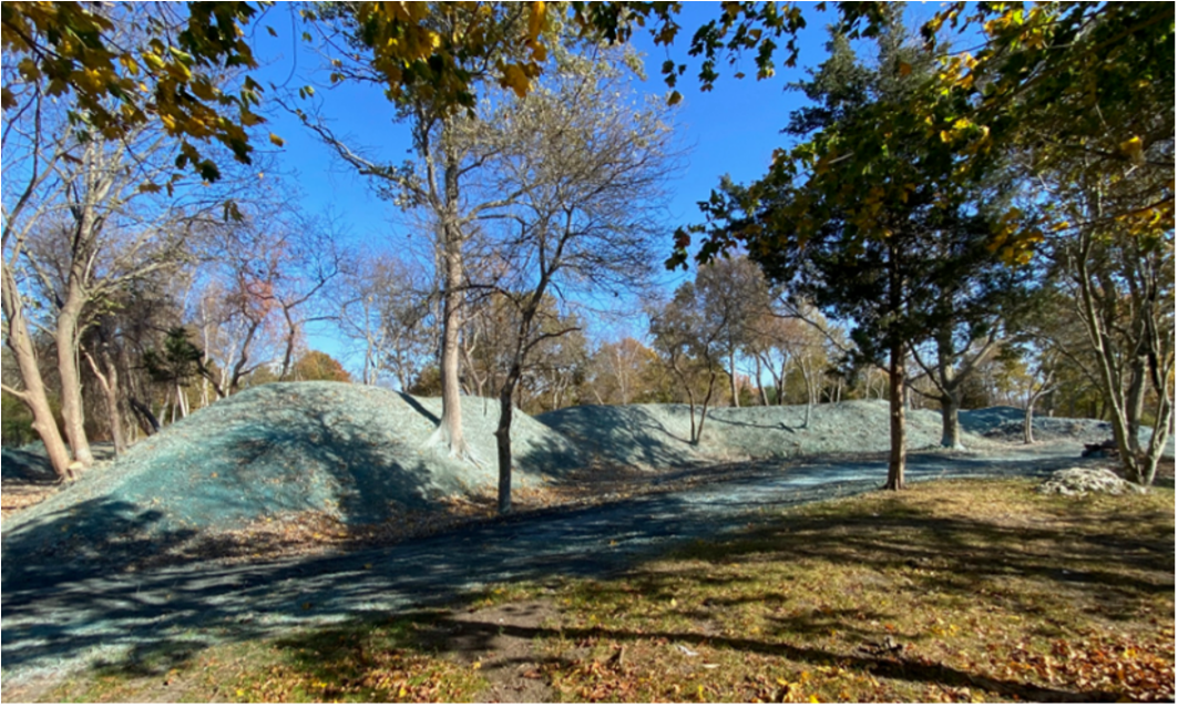
For 2024, The Butts Hill Fort Restoration Committee (BHFRC) set the ambitious goal of clearing, improving and stabilizing the multi-acre southern battery of Butts Hill Fort, essentially accomplishing an “extreme makeover”, transforming the thickly-tangled brush and invasives-ridden site into an open historic campus with complete access and visibility of the almost 250-year-old earthworks. The goals included connecting level pathways and unobstructed view corridors to Quaker, Turkey and Durfee hills to the South, and to the East to Howland’s Ferry and Tiverton. We’ve also added an information hub to our website for all things related to the Butts Hill Fort Restoration.
A request from the Battle of Rhode Island Association in the fall of 2022 to replace 5 old W3R-US (W3R) signs in Portsmouth became a 2-year effort by the RI Department of Transportation (RIDOT) to replace all these signs in RI.
In November 2023, the Rhode Island Department of Transportation (RIDOT) initiated a comprehensive effort to replace and install approximately 126 signs marking the Washington-Rochambeau Revolutionary Route National Historic Trail (WARO) across Rhode Island. This project, led by RIDOT’s Sean Raymond and Ted Coleman, spans multiple towns and cities including Coventry, Scituate, Cranston, Providence, East Providence, Barrington, Warren, Bristol, Portsmouth, Middletown, and Newport
The new signs feature a 24×24 inch brown background with the WARO logo and white lettering reading “Washington Rochambeau,” accompanied by directional arrows.
This initiative builds upon earlier signage efforts that began in 2005 by W3R. W3R, a non-profit organization formed in 2001, has been instrumental in preserving and promoting this historical trail that was part of a broader initiative to commemorate the 225th anniversary of the American Revolution.
In May 2006, Rhode Island installed about 140 route markers along the W3R route and a gateway sign was placed on Route 14 at the Connecticut border in 2010.
The Washington-Rochambeau Revolutionary Route National Historic Trail (WARO), established by Congress as a National Park Service unit in 2009, commemorates the alliance between French and Continental armies during the American Revolution. It covers more than 700 miles across nine states and Washington D.C., following the route taken by Generals Washington and Rochambeau from Newport, RI to Yorktown, VA. Johnny Carawan, based near Philadelphia, serves as the Trail Administrator for WARO, overseeing its development and partnerships with local organizations and historical sites. Information on WARO can be found at https://nps.gov/waro/index.htm.

BoRIA was awarded $5,000 to support talks and a “Brits attack Bristol” event in 2025. This is their fourth grant to BoRIA, Massachusetts Society of the Cincinnati (MA SoC) being one of our earliest supporters starting in 2021. The MA SoC is one of the fourteen constituent societies of the Society of the Cincinnati, a hereditary organization founded in 1783 to commemorate the American Revolutionary War. Membership is restricted to male descendants of Continental Army or Navy officers who served in the Revolutionary War.

On Monday, December 16th, members of the Butts Hill Fort Restoration Committee (BHFRC) and the Battle of Rhode Island Association (BoRIA) were on hand at Hathaway Elementary school in Portsmouth for a special check presentation. A 2nd grade student, Brayan Chiaro, won a “golden ticket” from the Feinstein Foundation, awarding him $500 to donate to the charitable organization of his choice. He chose Butts Hill Fort. Paul Murphy, BHFRC Chair and BoRIA Director added, “We would like to thank Brayan for making Butts Hill Fort preservation efforts his Feinstein Foundation Golden Ticket choice. We were truly inspired by the hundreds of fired up Hathaway Elementary school kids, because we want to save our shared American heritage for them as it was done for us by our predecessors, and these youngsters will be Portsmouth’s stewards of the future.” Brayan is the son of Seth Chiaro, the military advisor to BoRIA.

Even though the founder of the state of Rhode Island settled in Providence in 1636 – 140 years before the Revolution, you may be surprised to know that Roger Williams is making an appearance in our FreshMaps “Revolutionary RI History Hunt” series. For the Providence segment, we have partnered with historian and actor, John McNiff, who writes:
“If American Independence is a result of enlightenment thought, Roger Williams laid the practical foundation stones more than 140 years earlier in 1636. The ideals expressed by Williams, and embedded in RI’s colonial Charter of 1663, that the foundation of civil power lies in the people, that government and religion need to be kept separate, that the people should have a voice in how their government is run, all started here in Providence. Many other philosophers had thought these thoughts. Williams put them into practice. It was a colony founded by outcasts, called a haven for rogues, and always did things a little bit differently than the other colonies.”
This hunt features stops at Roger Williams National Park, Prospect Park, First Baptist Church, John Brown House, Stephen Hopkins House, the old and new state houses and Gano Park. New learning maps are currently being developed in Bristol with Bristol Historic & Preservation Society, with Coventry’s Nathanael Greene Homestead, and in East Greenwich with the Varnum Armory and Varnum House.
By Norman Desmarais

Comte Jean Baptiste Charles Henri Hector d’Estaing (1729–1794) held positions as admiral in the French navy and major general in the French army. Five weeks after King Louis XVI signed the Treaty of Amity and Commerce, in February 1778, whereby France sided with the Americans in their war of independence, the admiral left France with 12 ships of the line (equivalent to today’s battleships), 3 frigates and a number of transports, all bringing some 4,000 French soldiers to America. By the end of July, the powerful French fleet had made its way to Narragansett Bay, where d’Estaing planned to cooperate with an American army under the command of Major General John Sullivan to capture Newport, as well as the rest of Aquidneck Island, from a British occupying force.
By Christian McBurney

A 1778 map of the Delaware River below Philadelphia showing the positions of Fort Mercer on Fort Island, Fort Mifflin on Red Bank, and the Chevaux-de-frise at points across the river. A sketch of the profile and plan of the Chevaux-de-frise is at the bottom right. (Library of Congress).
The author recently came across the recollections of Simeon Thayer, who served from 1777 to 1781 as a major in Rhode Island Continental Army regiments. He was one of the outstanding military figures from Rhode Island during the war. His recollections start with him as a teenager during the French and Indian War serving in Maj. Robert Roger’s ranger corps, engaging in battles in the forests with Indian enemies. He barely survived becoming a prisoner at the infamous surrender of the British garrison at Fort William Henry.
Read an Article and Win some Gear!

How do I enter?
You can enter our monthly raffle by reading any of our articles and filling out the form at the bottom of the article page. Entering the contest will also add you to our mailing list, which you can opt out of at anytime. Winners will be chosen at the beginning of each month and notified via the email they used to register. Limit one entry per person per month. Enter every month to increase your odds of winning!
Congratulations to our June contest winner Tori from Rumford, RI.
Did You Know?
Did you know that Jamestown, Rhode Island (Conanicut, Dutch, and Gould Islands) played a significant role during the Revolutionary War?
- Guardian of the Bay: All large vessels entering the bay had to pass by Jamestown, where its battery of cannons 100 feet above the sea dominated maritime traffic. Initially, rebel forces defended the island.
- British control: In December 1776, British forces landed and garrisoned in Jamestown and Newport, taking control of the lower Bay until 1779, except for a brief period in August 1778.
- Loyalists: Allegiances in the town split between loyalists and rebels. Many were Quakers opposed to war, others aligned with British trade, and many African Americans sought their freedom from the British. Massachusetts Tory Governor Hutchinson owned a 640-acre estate on the island which was confiscated when the British left.
- Rebel defenses: Defenses were meager in early 1775 when the town ordered 50 lb. gunpowder, 80 lb. lead, and 320 flints for its militia. In June, the first rebel naval attack occurred between Gould and Conanicut Islands upon the British customs revenue sloop Diana, setting fire to its powder chest. The sloop ran ashore, and the sailors hid in Jamestown until the next day.
- Population Decline: In August 1775, rebels removed most cattle and sheep from the island to thwart British requisitions during the Revolution. This hastened a collapse in Jamestown’s population from almost 600 to about 350 residents.
- Burning of Jamestown: Conanicut rebels fired repeatedly on British ships from the island until they killed a British boatswain. Captain James Wallace then landed in December 1775 with 200 marines and sailors and dozens of African American loyalists who “piloted him about the island and pointed out the houses to burn.” They burnt 15 houses, many barns, confiscating 50 cattle, other livestock, and the “ladies finest dresses.” One resident was killed.
- Fortifications: The Conanicut Battery, built in 1776, was the first known fortification on the island. It was a lozenge-shaped earthwork battery, approximately 150 feet long and 75 feet wide, situated 90 feet above sea level. The British improved and re-armed the Conanicut Battery by installing powerful 24-pound cannons.
- French Occupation: In 1778, the British fired upon the French ship Sagittaire from the Conanicut Battery as it entered the bay. French forces then briefly occupied Jamestown.
- Post-War Recovery: After the war, Jamestown residents requested land confiscated from Governor Hutchinson to build a windmill for grinding grain, which was constructed in 1787.
- Social Impact: The war disrupted Jamestown’s economy, which had previously relied on slave labor to export agricultural products to Newport and the world. In 1778, at least eight enslaved Jamestown African Americans joined Rhode Island’s 1st Regiment, obtaining their freedom. Other slaves fled or were freed, while some remained enslaved for another half-century.

